Okanogan-Wenatchee National Forests Washington, USA One of five new Trails Illustrated maps for the Washington Cascades region offering the most detailed and up-to-date map for the forest, carefully researched and developed in co-operation with local land managers and agencies. Each map contains easy to read trails, numbered forest service roads, campsites, access points, scenic points-of-interests, and important facilities. The Glacier Peak W...
Part of our exciting new coverage for Californias Sierra Nevada, our Carson-Iceberg, Emigrant & Mokelumne Wilderness Trails Illustrated map details the high use recreation areas of Stanislaus & Humboldt-Toiyabe National Forests from Yosemite National Park north to Caples Lake and Markleeville. This popular stretch of the Sierras contains year-round recreation opportunities for outdoor enthusiasts of all interests. Like all National Geographic ...
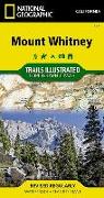
- Waterproof - Tear-Resistant - Topographic MapMount Whitney is universally famous as the highest peak in the contiguous United States, as well as the highest point in California. National Geographic's Trails Illustrated map of Mount Whitney delivers unmatched detail and valuable information to assist you in your exploration of this beautiful region. Expertly researched and created in partnership with local land management agencies, this map f...
- Waterproof - Tear-Resistant - Topographic MapLocated just north of Yellowstone National Park, Absaroka-Beartooth Wilderness is known for it high peaks and alpine plateaus. Experienced and novice outdoor enthusiasts alike will marvel at National Geographic's Trails Illustrated map of Absaroka-Beartooth Wilderness West. Expertly researched and created in cooperation with the National Park Service, U.S. Forest Service and others, the map delive...
- Waterproof - Tear-Resistant - Travel MapThe United Kingdom Adventure Map is combined with a London Destination City map in this Map Pack bundle. The United Kingdom map is filled with interesting places to visit throughout this historially rich country. From the White Cliffs of Dover through the heart of England all the way to the Shetland Islands of Scotland this map covers it all. Combine the Adventure Map of the United Kingdom with a beaut...
National Geographic's Trails Illustrated Maps are the most detailed and up-to-date topographic recreation maps available for US National Parks, National Forests and other popular outdoor recreation areas. A necessity for exploring the outdoors, each map is printed on waterproof, tear-resistant material. They also contain key safety and contact information, GPS and compass coordinates, Leave No Trace ethical guidelines and hundreds of points-of...
National Geographic's Trails Illustrated Maps are the most detailed and up-to-date topographic recreation maps available for US National Parks, National Forests and other popular outdoor recreation areas. A necessity for exploring the outdoors, each map is printed on waterproof, tear-resistant material. They also contain key safety and contact information, GPS and compass coordinates, Leave No Trace ethical guidelines and hundreds of points-of...
National Geographic's Trails Illustrated Maps are the most detailed and up-to-date topographic recreation maps available for US National Parks, National Forests and other popular outdoor recreation areas. A necessity for exploring the outdoors, each map is printed on waterproof, tear-resistant material. They also contain key safety and contact information, GPS and compass coordinates, Leave No Trace ethical guidelines and hundreds of points-of...
The newly redesigned National Geographic DestinationMaps series strikes the perfect balance between map and guidebook, and they are the ideal resource for touring culturally and geographically unique areas. All maps are double-sided with beautiful photos and detailed travel information, including comprehensive road networks, local information and natural, historical and cultural places of interest. The maps are printed on durable, waterproof, ...
The newly redesigned National Geographic DestinationMaps series strikes the perfect balance between map and guidebook, and they are the ideal resource for touring culturally and geographically unique areas. All maps are double-sided with beautiful photos and detailed travel information, including comprehensive road networks, local information and natural, historical and cultural places of interest. The maps are printed on durable, waterproof, ...
- Waterproof - Tear-Resistant - Topographic MapCovering 630 square miles in southeast Georgia, the Okefenokee National Wildlife Refuge encompasses nearly all of the world-renowned Okefenokee Swamp. Expertly researched and created in partnership with local land management agencies, National Geographic's Trails Illustrated map of Okefenokee National Wildlife Refuge provides an unparalleled tool for exploring this magnificent wetland. This map of...
An arrangement of Kenny Loggins' rock hit is from the movie Top Gun. The familiar driving bass line is the foundation for this energetic box office favorite. Soaring aerobatic ecstasy! This title is available in MakeMusic Cloud. (2:15)
An arrangement of Kenny Loggins' rock hit from the movie Top Gun. The familiar driving bass line is the foundation for this energetic box office favorite. Soaring aerobatic ecstasy! This title is available in MakeMusic Cloud. (2:15)
Your players will really eat this up! Many students will already be familiar with the goofy lyrics from the viral YouTube video about this favorite fast food. Shell, meat, lettuce, cheese!" Fun to play, this wacky piece is sure to be a hit! (1:45)
Your players will really eat this up! Many students will already be familiar with the goofy lyrics from the viral YouTube video about this favorite fast food. Shell, meat, lettuce, cheese!" Fun to play, this wacky piece is sure to be a hit! (1:45)
Indisputably one of the most significant concert band masterworks from the early 20th century. Respecting the dignity and historical significance of this band masterwork, this is a complete and unabridged scoring. Guaranteeing accessibility for developing bands, level-appropriate instrumentation, ranges, rhythms, key signatures, and meters have all been followed. Must-have repertoire for every library. A contest winner! (12:30) This title avai...
Indisputably one of the most significant concert band masterworks from the early 20th century. Respecting the dignity and historical significance of this band masterwork, this is a complete and unabridged scoring. Guaranteeing accessibility for developing bands, level-appropriate instrumentation, ranges, rhythms, key signatures, and meters have all been followed. Must-have repertoire for every library. A contest winner! (12:30) This title is a...
National Geographic's Trails Illustrated Maps are the most detailed and up-to-date topographic recreation maps available for US National Parks, National Forests and other popular outdoor recreation areas. A necessity for exploring the outdoors, each map is printed on waterproof, tear-resistant material. They also contain key safety and contact information, GPS and compass coordinates, Leave No Trace ethical guidelines and hundreds of points-of...
Bring an exciting element to science class when you use Evan-Moor's Science Lessons and Investigations for sixth grade. This teacher's edition follows Next Generation Science Standards (NGSS) in life, earth, and physical science throughout 14 engaging science units.
![Green Mountain National Forest North Map [Moosalamoo National Recreation Area, Rutland]](https://support.digitalhusky.com/media/annotations/sorted/194/19455291/CHSBZCOP0319455291.jpg)

![Glacier Peak Wilderness Map [Mt. Baker-Snoqualmie and Okanogan-Wenatchee National Forests]](https://support.digitalhusky.com/media/annotations/sorted/194/19451864/CHSBZCOP0319451864.jpg)
![Carson-Iceberg, Emigrant, and Mokelumne Wilderness Areas Map [Eldorado, Humboldt-Toiyabe, and Stanislaus National Forests]](https://support.digitalhusky.com/media/annotations/sorted/194/19451861/CHSBZCOP0319451861.jpg)
![Absaroka-Beartooth Wilderness West Map [Gardiner, Livingston]](https://support.digitalhusky.com/media/annotations/sorted/194/19411366/CHSBZCOP0319411366.jpg)
![United Kingdom, London [map Pack Bundle]](https://support.digitalhusky.com/media/annotations/sorted/263/26317968/CHSBZCOP0326317968.jpg)
![Mount Hood Wilderness Map [Mount Hood National Forest]](https://support.digitalhusky.com/media/annotations/sorted/124/12488642/CHSBZCOP0312488642.jpg)
![Manistee South Map [Manistee National Forest]](https://support.digitalhusky.com/media/annotations/sorted/124/12488633/CHSBZCOP0312488633.jpg)


![Crystal Basin, Silver Fork Map [Eldorado National Forest]](https://support.digitalhusky.com/media/annotations/sorted/331/3313533/CHSBZCOP033313533.jpg)